28-29 Sepember 200
It is a bit of a trek to Scafell, allow up to 4-5 hours, as some of the roads are narrow – POSSIBILITY OF A MINIBUS IF DEMAND IS THERE
There is the Wasdale
Hall YH close at hand and the wasdale Head Inn just up the road for a
wee drink (Note it was shut on a Sunday last time I was there, as were
all the pubs between there and Penrith). YH accomm is available for
a fee of £10.25pppn Breakfast is £3.40 and eve meals are £5.00, but I
am sure the Inn also does food.
Leave
Wasdale Inn on the road southwards, passing a public carpark in
about 200 metres. Continue south for another 200 metres to a bend in the
road where a path to the left is signposted to "the Scafells". The grassy
fields are crossed over Lingmell Beck and then left for bracken-covered
open ground as the path rises.
As you climb up the path, keep an eye to the west
and the views opening up along Wast Water. The path enters the steep-sided
valley of Lingmell Gill and climbs along the east bank of the small stream.
The gradient is not too bad but the climbing is quite steady along a track
that starts off as well-formed but becomes more eroded further up the
valley. A last view along Wast Water is visible from Brown Tongue where
the stream forks and the path crosses over to climb the tongue itself.
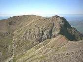
Of more importance are the buttresses of Scafell Crags ahead which begin
to loom over the valley.
A slightly steeper climb brings you into the head
of the valley under the crags where there is a choice of scree slopes
to climb. An obvious path leads straight up the scree in front of you
to the col of Mickeldore. A boulder field to the left successfully conceals
the route up to Lord's Rake - a narrow shoulder-width passage traversing
through the base of Scafell Crags up onto the west side of Scafell.
A path climbs over stony ground from Mickeldore and
rises up the side of a ridge to Scafell Pike at a height of 987 metres
(3208 feet). There is quite a bit of "furniture" on the summit, including
a semi-circular wall providing welcome shelter from any wind. The views
are tremendous. To the north-east, there is the gray cone of Great
Gable with the path climbing its rocky slopes looking quite flat from
this height. On the horizon above Styhead Pass, you can see the far-off
summit of Skiddaw and the green fields of Borrowdale leading up to the
shores of Derwentwater lake. The bald summits of Broad Crag and Great
End are closer to hand - a path is visible winding over Broad Crag heading
for Esk Hause and an easy descent to Styhead Pass.
This is where I got a little confused - I was still
fixed on my original idea of going to Scafell first. Thus I wandered off
on the clear path dropping to the east (this is the Corridor Route that
ends up at Styhead Pass). My mistake became obvious when I looked up and
saw the knob of Lingmell in front of me. This turned out to be a lucky
mistake since I actually continued down the route to a dramatic gorge
dropping down into Wasdale - worth the 25 minute detour.
A short climb back to Scafell Pike and a nice descent
gets you back to Mickeldore. Head south under Symond's Knott to
have a look at a cleft cut into the crags. The guidebooks are right when
they say that it is really a climbers route up to Scafell. Continue down
the slippery scree slopes to where a tiny stream emerges from a fissure
in the cliff walls. This is the route up to Foxes Tarn - an interesting
clamber up the tiny gorge, often over boulders and with moss-covered walls
at your shoulders. The gorge emerges into a small bowl under Scafell with
the even-smaller tarn to one side. A well-constructed path then rises
in zigzags up to the ridge between Symond's Knott and Scafell. The summit
at 974 metres (3162 feet) is a couple of minutes along the ridge. More
good views await you.
CONFIRM
ACCOM/TRANS BY THE 12th SEPTEMBER PLEASE
Affiliated
Membership of:
Mountaineering Council of Scotland
Scottish Youth Hostels Association
© 2026 All Rights Reserved